


 Following the work we had done on recording abandoned lead mines here in Mid Wales for the RCAHMW, we succeeded in bidding for a survey project in Ireland. Tankardstown mine in Bunmahon, Co. Waterford is part of the Copper Coast Geopark. Sited on the seacliffs to the East of the village, the impressive engine house and chimney stack are still in relatively good repair. Underneath the workings, there lies a veritable rabbit warren of tunnels and shafts, extending some 300m under the shaft head and 12.5Km in extent, judging by the late 19th Century mines plan. The majority of the workings are now inaccessible due to flooding and cave-ins, but some 500m of the tunnels can still be entered by experienced mine explorers.
A project of this nature requires some detailed paperwork to ensure access to the site, insurance cover for the kit and people, detailed risk and equipment assessments to ensure we could handle anything the mine could put in our way. GSS/DJA assembled a pretty unique team, Hugh is a very experienced mine explorer, Mikey is an ace photographer and our Irish crew of Sean, Brian and Jim got our kit (and us) down and back out the mine with minimal hassle. Stuart at Opti-Cal sorted us out with a Faro Focus scanner and Leica GS15 tied to the Irish OS network and all of the survey work was tied together using our faithful Leica TPS1203 total station.
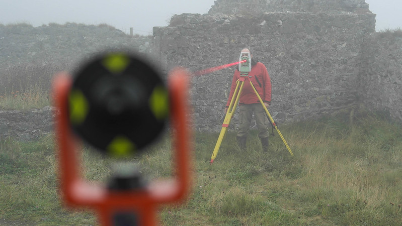 The surface works were a straightforward (if damp) day of scanning and pano photography – a gentle introduction to the site.
Access to the mine is via an adit located some 8m above the beach, at the bottom of a steep and loose gully, or via a 45m shaft from the roadside. The access adit was waist deep in water, but thanks to a bit of mining work by Hugh, this dropped to thigh deep. This meant a chilly trip to work each morning! Inside the mine was generally dry, but typically muddy. Another adit ran out of the cliff face further to the west, allowing us to carry out a traverse loop to locate the bottom of the shaft and resection to survey points on the clifftop. Even at low tide, this meant carrying out total station work in knee deep seawater to be able to see the survey points at the top of the cliff, but at least it cleaned off the mud from the mine....
Scanning
For the surface works, we carried out 26 scans, giving a good coverage of the buildings and allowing us to get close enough to couteract the effect of the fog lying on the site. Underground, we recorded 56 scans using the Focus 3D, referenced to our total station traverse using spherical targets, which was tied in to the OSI grid using the RTK GPS.
Photography
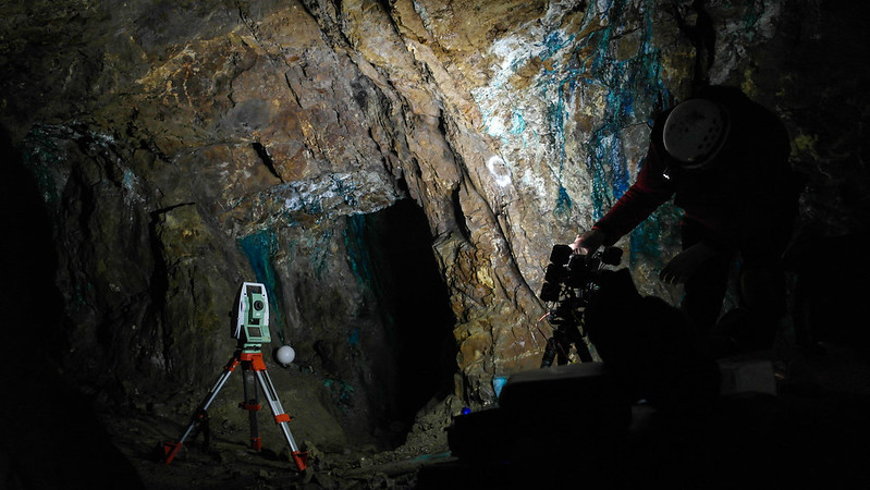 Due to the nature of the project and prior experience with getting good images underground, we built a LED powered light rig for our camera and made use of exposure bracketing and HDR imaging to capture as much of the fantastic colour and detail as possible. Over a thousand images were taken for the panoramic aspect of the project and cooked down to create the panoramic tours of the surface works and underground.
Deliverables
As well as the scan data and photos, we also received a set of mine plans from the team at Copper Coast. These were modelled up in 3D and tied in to the survey data to give a true 3D representation of the site and the workings below it. Two short animated flythroughs were created and panoramic tours of the site made available online. Here are the panoramic tours:


Here's the animated flythrough of the mine using the scan data from the surface and the underground working:
For more of Mikey's excellent photos, see here....